Egypt Field Report #3
November 16, 2019
It’s amazing to me that we can board an airplane and be just about anywhere in the world in 24 hours. I have returned from Cairo to London and will leave tomorrow for Baltimore. In the meantime I thought it best to fill you all in on some details that most tourists don’t know about.
Be forewarned! Anything within C programming comments may not be completely true.
i.e.
/* This starts a comment.
There can be many lines in-between.
And this ends the comment. */
This report is being filed not only by myself but also Bryce Holliwell, my alter ego. I am not responsible for the comments of Mr. Holliwell. Rest assured everything within the comments sections will be his doing.
Let’s get oriented – Egypt, Cairo.
Cairo is on the east bank of the Nile.
On the west bank it’s called Giza.
Going further west you reach The Western Desert.
The Nile floods every year and silt washes up on the banks.
In the 1960s Nasser the then premier of Egypt built the Aswan Dam, which helped control the flooding and provided the people with water year round. It also reduced the area of land that got flooded every year. Much building has gone on in this rich fertile area. You will find palm trees and lush green fields next to buildings or dry barren land. Trash is everywhere. Much of it is thrown on the roofs or into the canals.
As you travel out of Cairo into Giza you will come to The Western Desert. All along the edge of this desert the ancient Egyptians built tombs and temples, for 4,500 years.
Beginning in the north, closest to the Mediterranean Sea, you have the Giza Plateau where the three great pyramids of Giza are built. The government is building a huge new museum nearby and access to the plateau at Giza is near the edge of the city. This is not the case for the other areas of the Western Desert, access is controlled by the military.
Going south from Giza you come to the areas known as (in order):
Zawyet El-Aryan,
Abut Ghurab,
Abusir,
Saqqara,
Dahshur,El-Lisht,
Meidium,
Hawara,
and finally
El-Lahun.
All these area have temples, pyramids and other structures.
Many have of these structures have inner corridors, chambers, and passageways; of which we saw and explored many of them.
/* What is little known is that many of these structures have inner chambers and in the innermost of these chambers have coffee, cocktail, and sometimes juice bars. */
Some terminology that you might want to know.
Pyramids – four sided things that build to a point.
Mastabas – four sided things that have a flat top.
Temples – generally lots of columns and walkway, often called a processional causeway.
To the untrained eye most mastabas and many pyramids look like piles of stone. Temples look like scattered stones with a few bits of wall, column and entryway thrown in, plus odd stones here and there.
On my tour we went to the Giza Plateau for a general walk about. That was on day three. (Day one was check in.)

On Day 2 (Nov 10, 2019) we went to The National Museum of Egyptian Civilization. This is one of five new museums the Egyptian Government is creating. Only two floors in a small gallery were open but interestingly there was a small gold covered coffin there. The recent story of this coffin is what makes it so interesting. It showed up at the Metropolitan Museum n New York! They had paperwork showing it was a new discovery, etc. etc. etc. The Egyptians said no. It was taken from our museum during the recent time of chaos when we were more worried about what was going on in the streets than in the museums.
We also went to the Coptic Museum that day and to the Hanging Church, so named because it is suspended on two towers. You’d never know it, except for the glass covered holes, which allow you to peer through and see the ground farther below. (The question as to why they suspended the church in this way was not answered.)
More on Day 3: The general walk about included seeing some of the smaller tombs and ruins on the site. This included seeing the Sphinx. I found its location surprising. The pyramids of Giza sit on a high plateau. The Sphinx is downhill from them. Most pictures I have seen make it appear to be on the same level as the pyramids. this is not true. In fact, from where we exited the ruins of the mastabas (that’s the name for the more flat roofed tombs) we could look down hill to the Sphinx. It’s easy from that vantage point to understand why the Sphinx was covered up to its neck for years. It’s on the fall line of most of the water that would run off the hill!

Part of the reason for the Sphinx to be on that fall line is that the confluence of two sides of the plateau seem to join at that point. However, part of the reason for this is that it is believed that many of the blocks that were used on the Great Pyramid of Khufu and the Pyramid of Khafre were taken from that area. There is a causeway leading down the hill from Khafre’s pyramid toward the Sphinx and it has to divert to move around the Sphinx. Whether this causeway was a processional ceremonial causeway or merely a way to drag the stones to the construction site of Khafre’s Pyramid is not clear to me.
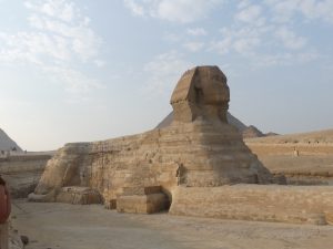
A more classic view
On Day 4 we drove four wheeled drive vehicles to the edge of the Western Desert near Abu Ghurob. This is just south of the Giza Plateau and you can see the Great Pyramid from there. However, you enter through a military controlled checkpoint and you need the four wheeled vehicles to get through the areas of soft sand. If one is not familiar with the techniques for driving in these conditions it would be easy to get stuck. We were split into five vehicles, four to a vehicle. Our driver was skilled in keeping us out of the dust created by the other vehicles and in knowing when to speed up on the hard pack to get through the approaching soft sand. On one valley he raced down the side of the hill and maintained speed as he went up the far side never letting up. As we approached the crest of the far side of the valley I understood his reasoning. The was a lip of soft sand that had blown over the edge, without enough speed we would not have made it through and onto the top of the ridge. I looked to my right to see one of our Land Rovers grinding itself deep into the sand before making the ridge. That driver had to give up and back down for another try.
That is all. I must prepare to catch my flight from London to home.
Leave a Reply